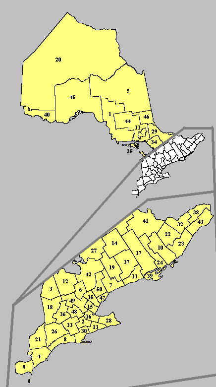
In the Canadian province of Ontario, there are three different types of census divisions: single-tier municipalities, upper-tier municipalities (which can be regional municipalities or counties) and districts. They differ primarily in the services that they provide to their residents.
The varying structures of municipal and regional governments in Ontario can sometimes be confusing, as they result from a variety of approaches to local government, implemented at different times by different provincial governments in specific areas to serve specific needs. Due to the vast disparities among Ontario's different regions, it would be extremely difficult for a provincial government to apply a consistent, unified system across the entire province.
In some cases, as well, a census division may retain its historical name even if it changes government type (eg. Oxford County, Haldimand County, Norfolk County and Prince Edward County are no longer counties even though they retain "county" in their name; Oxford is a regional municipality and the others are single-tier municipalities.)
These divisions are used by Statistics Canada to aggregate census data. A smaller municipality within a census division is called a census subdivision.
Several census divisions in Ontario have significantly changed their borders or been discontinued entirely. For more information, see also Historic counties of Ontario.
The following data is based on 2006 Community Profile by Statistics Canada. [1]
|
1. Algoma (pop. 117,461) |
26. Middlesex (pop. 422,333) |
Single-tier municipalities[]

A single-tier municipality is a census division which is governed by one municipal administration, with neither a county nor regional government above it, nor further municipal subdivisions below it (cf. independent city). A single-tier municipality is either a former regional municipality or a former county, whose municipal governments were amalgamated in the 1990s into a single administration. A single-tier municipality should not be confused with a separated municipality, which is a municipality that is administratively separated from its county, but is not considered a separate census division.
A single-tier municipality which is predominantly urban in nature may also be informally referred to as a megacity. Single-tier municipalities of this type (Toronto, Ottawa, Hamilton and Greater Sudbury) were created where a former regional municipality consisted of a single dominant urban centre and its suburbs.
- Municipality of Chatham-Kent, formerly Kent County (seat in Chatham)
- City of Greater Sudbury, formerly the Regional Municipality of Sudbury
- Haldimand County, formerly half of the Regional Municipality of Haldimand-Norfolk* (seat in Cayuga)
- City of Hamilton, formerly the Hamilton-Wentworth Regional Municipality
- City of Kawartha Lakes, formerly Victoria County (seat in Lindsay)
- Norfolk County, formerly half of the Regional Municipality of Haldimand-Norfolk* (seat in Simcoe)
- City of Ottawa, formerly the Regional Municipality of Ottawa-Carleton
- Prince Edward County (seat in Picton)
- Brant County* (seat in Burford)
- City of Brantford*
- City of Toronto, formerly Metropolitan Toronto
(* Brant County and the City of Brantford were still considered a single census division by Statistics Canada in 2001, even though they are two separate single-tier municipalities. Although Haldimand-Norfolk split in 2001 to become the single-tier municipalities of Haldimand County and Norfolk County, they were still considered a single census division by Statistics Canada in that year's census. This was not the case in 2006.)
Regional municipalities[]

Regional municipalities (or regions) are upper-tier municipalities that generally have more servicing responsibilities than the counties. They generally provide the following services: maintenance and construction of arterial roads, transit, policing, sewer and water systems, waste disposal, region-wide land use planning and development, as well as health and social services. Regions are typically more urbanized than counties. Regional municipalities are usually implemented in census divisions where an interconnected cluster of urban centres forms the majority of the division's area and population, but no single centre is overwhelmingly dominant over the others.
Current regional municipalities in Ontario, with regional seats listed in brackets:
- Durham (Whitby)
- Halton (Milton)
- Muskoka District (Bracebridge)
- Niagara (Thorold)
- Oxford County (Woodstock)
- Peel (Brampton)
- Waterloo (Kitchener)
- York (Newmarket)
Although Oxford County and the District Municipality of Muskoka are not called regions, they are defined as regional municipalities under Part 1, Section 1 of the Ontario Municipal Act, 2001.
Between 1998 and 2001, four regional municipalities that were dominated by a single city were amalgamated. In 1998, the Municipality of Metropolitan Toronto became the amalgamated City of Toronto. In 2001, the Regional Municipality of Ottawa-Carleton became the City of Ottawa, the Regional Municipality of Hamilton-Wentworth became the City of Hamilton, and the Regional Municipality of Sudbury became the City of Greater Sudbury. At the same time, the Regional Municipality of Haldimand-Norfolk was split into Haldimand County and Norfolk County.
Counties[]

Counties have fewer responsibilities than regions, as the lower-tier municipalities (cities, towns, villages, townships) within the counties typically provide the majority of municipal services to their residents. The responsibilities of county governments are generally limited to the following: maintenance and construction of arterial roads, health and social services, and county land use planning. Counties are only found in Southern Ontario.
Counties may be as large as regional municipalities in population, but their population density is generally lower (although not as low as in a district.) Counties may include major cities, such as London, Kingston and Windsor, but these cities have generally not evolved into urban agglomerations with other communities, as in regions and "megacities".
Counties may also include separated municipalities, communities that are considered part of the county for census purposes but are not administratively connected to the county. Municipalities are separated when regional or single-tier status is not appropriate for the municipality's population patterns, but their population is still large enough that it may adversely affect the county's ability to provide services to its smaller communities.
County seats in brackets.
- Bruce County (Walkerton)
- Dufferin County (Orangeville)
- Elgin County (St. Thomas)
- Essex County (Windsor)
- Frontenac County* (Kingston)
- Grey County (Owen Sound)
- Haliburton County (Minden)
- Hastings County (Belleville)
- Huron County (Goderich)
- Lambton County (Wyoming)
- Lanark County (Perth)
- Leeds and Grenville United Counties (Brockville)
- Lennox and Addington County (Greater Napanee)
- Middlesex County (London)
- Northumberland County (Cobourg)
- Perth County (Stratford)
- Peterborough County (Peterborough)
- Prescott and Russell United Counties (L'Orignal)
- Renfrew County (Pembroke)
- Simcoe County (Barrie)
- Stormont, Dundas and Glengarry United Counties (Cornwall)
- Wellington County (Guelph)
(* Frontenac County exists only by name, and was actually abolished in 1998. While the Frontenac Management Unit does oversee a limited number of services shared by Kingston and the townships, it does not exist as a typical Ontario county.)
Districts[]

Districts are regional areas in Northern Ontario, but these are simply territorial boundaries that do not serve any municipal government purpose. Many of these districts are composed primarily of unincorporated lands. Some districts may have District Social Service Administration Boards, which are designed to provide certain social services, but they do not serve a governmental function.
In a district, all services are provided either by the local municipality or directly by the provincial government. Much of Northern Ontario is sparsely populated, so a county government structure would not be an efficient or cost-effective method of administration. Only one census division in Northern Ontario, the city of Greater Sudbury, has a local government which offers county-type services.
District seats are in parentheses.
- Algoma District (Sault Ste. Marie)
- Cochrane District (Cochrane)
- Kenora District (Kenora)
- Manitoulin District (Gore Bay)
- Nipissing District (North Bay)
- Parry Sound District (Parry Sound)
- Rainy River District (Fort Frances)
- Sudbury District (Espanola)
- Thunder Bay District (Thunder Bay)
- Timiskaming District (Haileybury)
See also[]
- Subdivisions of Canada
- List of Ontario census divisions by population
- List of communities in Ontario
External links[]
| |||||||||||||||||||||||
References[]
- ^ http://www12.statcan.ca/english/census06/data/profiles/community/Index.cfm?Lang=E 2006 Community Profiles
| This page uses Creative Commons Licensed content from Wikipedia (view authors). |