| Main | Births etc |
|---|
| Chilmark, Massachusetts | |
|---|---|
| — Town — | |
 |
|
 |
|
| Coordinates: Coordinates: | |
| Country | United States |
| State | Massachusetts |
| County | Dukes |
| Settled | 1660 |
| Incorporated | 1694 |
| Government | |
| • Type | Open town meeting |
| Area | |
| • Total | 100.4 sq mi (260.1 km2) |
| • Land | 19.1 sq mi (49.6 km2) |
| • Water | 81.3 sq mi (210.5 km2) |
| Elevation | 91 ft (28 m) |
| Population (2007) | |
| • Total | 963 |
| • Density | 50.4/sq mi (19.4/km2) |
| Time zone | Eastern (UTC-5) |
| • Summer (DST) | Eastern (UTC-4) |
| ZIP code | 02535 |
| Area code(s) | 508 / 774 |
| FIPS code | 25-13800 |
| GNIS feature ID | 0618288 |
| Website | http://www.chilmarkma.gov/Pages/index |
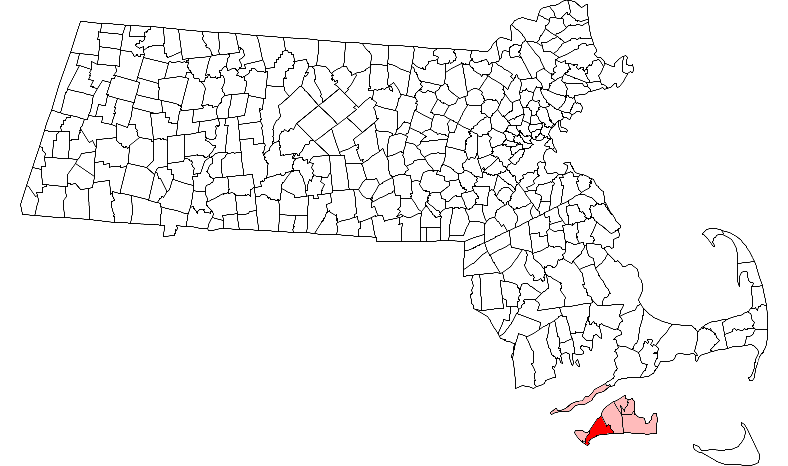
Chilmark is a town located on Martha's Vineyard in Dukes County, Massachusetts, United States. The population was 843 at the 2000 census. The fishing village of Menemsha is located on the northern end of town along its border with the neighboring town of Aquinnah. In 2005 it was confirmed to have the highest average property value of any city or town in Massachusetts.
History[]
Chilmark was first settled in 1660 by James Allen, William Peabody and Lt. Josiah Standish (son of Captain Myles Standish) in the southern portion of Tisbury. The town officially incorporated on September 14, 1694, the first town to separate from the two original towns of Tisbury and Edgartown. Chilmark was named for Chilmark in the English county of Wiltshire, the ancestral home of the family of Governor Thomas Mayhew of Tisbury, Wiltshire, England.
The town was once known for its unusually high percentage of deaf citizens. In 1854, Chilmark had a deaf population of one in every 25 people, while the national average was one deaf person in 5,728. (See Martha's Vineyard Sign Language.) Today the town is mostly residential, with a small working harbor along the Vineyard Sound side of the town.
In August 2009, 2010 and 2011, President Barack Obama and his family vacationed in Chilmark, renting the Blue Heron Farm.[1][2]
Geography[]
According to the United States Census Bureau, the town has a total area of 100.4 square miles (260 km2), of which, 19.1 square miles (49 km2) of it is land and 81.3 square miles (211 km2) of it (80.94%) is water. Chilmark ranks 192nd of the 351 communities in the Commonwealth in terms of land area. Chilmark is bordered by Vineyard Sound to the northwest, West Tisbury to the east, the Atlantic Ocean to the south and Aquinnah to the southwest.
The town includes the island of Noman's Land, which lies southwest of Martha's Vineyard. Because of the island, the town is officially the second most southerly point in Massachusetts (the south shore of Nantucket is approximately a kilometer south of the southernmost point on Noman's Land). Chilmark has a series of small ponds along the Atlantic side of the town, and it shares Tisbury Great Pond to the east and Menemsha Pond and Squibnocket Pond to the southwest, along the Aquinnah town line. It is between these two ponds, which are 1,100 feet (340 m) apart at their closest point, that the only road to Aquinnah passes. (Long Beach, privately owned, runs along the southern side of Squibnocket Pond and technically connects the towns. At one point in the late 17th and early 18th century, Squibnocket Pond was open to the sea. However,the barrier beach with its sand dunes eventually closed this opening permanently. Occasionally in winter storms, waves will wash across low points in the beach, but the beach itself has not been breached in a hundred years, unlike other barrier beaches on Martha's Vineyard.) Chilmark also has the highest point on Martha's Vineyard, at 311-foot-tall (95 m) Peaked Hill.
The town has several sanctuaries and preserves, the largest of which being the Menemsha Hills Reservation just north of the village which shares that name. The town also has six beaches; one is at Menemsha, another on the inner shore of Menemsha Bay, and the others are all along the Atlantic Coast. (Note that several of these beaches are restricted to owners only, and those designated as public require a beach pass.) There is also a boat launch in Menemsha, as well as a Coast Guard Station, which recently burned to the ground, in Mememsha Creek (harbor).
The town has no direct access to the mainland via ferry or by air; Martha's Vineyard Airport is in neighboring West Tisbury, and the Woods Hole Ferry is in Vineyard Haven, which is almost twelve miles (19 km) removed from the town center.
Demographics[]
| Historical population | ||
|---|---|---|
| Year | Pop. | ±% |
| 1850 | 747 | — |
| 1860 | 654 | −12.4% |
| 1870 | 476 | −27.2% |
| 1880 | 494 | +3.8% |
| 1890 | 353 | −28.5% |
| 1900 | 324 | −8.2% |
| 1910 | 282 | −13.0% |
| 1920 | 240 | −14.9% |
| 1930 | 252 | +5.0% |
| 1940 | 226 | −10.3% |
| 1950 | 183 | −19.0% |
| 1960 | 238 | +30.1% |
| 1970 | 340 | +42.9% |
| 1980 | 489 | +43.8% |
| 1990 | 650 | +32.9% |
| 2000 | 843 | +29.7% |
| 2001* | 854 | +1.3% |
| 2002* | 866 | +1.4% |
| 2003* | 871 | +0.6% |
| 2004* | 873 | +0.2% |
| 2005* | 871 | −0.2% |
| 2006* | 872 | +0.1% |
| 2007* | 883 | +1.3% |
| 2008* | 892 | +1.0% |
| 2009* | 897 | +0.6% |
| 2010 | 866 | −3.5% |
As of the census[13] of 2000, there were 843 people, 382 households, and 237 families residing in the town. The population density was 44.0 people per square mile (17.0/km²). There were 1,409 housing units at an average density of 73.6 per square mile (28.4/km²). The racial makeup of the town was 97.75% White, 0.36% African American, 0.12% Native American, 0.36% Asian, 0.71% from other races, and 0.71% from two or more races. Hispanic or Latino of any race were 0.83% of the population.
There were 382 households out of which 25.7% had children under the age of 18 living with them, 52.4% were married couples living together, 6.8% had a female householder with no husband present, and 37.7% were non-families. 29.6% of all households were made up of individuals and 9.2% had someone living alone who was 65 years of age or older. The average household size was 2.21 and the average family size was 2.71.
In the town the population was spread out with 20.8% under the age of 18, 4.0% from 18 to 24, 23.7% from 25 to 44, 32.7% from 45 to 64, and 18.7% who were 65 years of age or older. The median age was 46 years. For every 100 females there were 96.0 males. For every 100 females age 18 and over, there were 90.9 males.
The median income for a household in the town was $41,917, and the median income for a family was $63,750. Males had a median income of $35,469 versus $33,281 for females. The per capita income for the town was $30,029. About 5.7% of families and 7.6% of the population were below the poverty line, including 9.6% of those under age 18 and 4.3% of those age 65 or over.
Statistically, Chilmark ranks 324th in terms of population, and 311th by population density. It is the second smallest population on Martha's Vineyard (ahead of Aquinnah), but is the least densely populated town on the island.
Government[]
On the national level, Chilmark is a part of Massachusetts's 10th congressional district, and is currently represented by Bill Keating. The state's senior member of the United States Senate is Elizabeth Warren. The state's junior Senator is Ed Markey.
On the state level, Chilmark is represented in the Massachusetts House of Representatives as a part of the Barnstable, Dukes and Nantucket district, which includes all of Martha's Vineyard and Nantucket, as well as a portion of Falmouth. The town is represented in the Massachusetts Senate as a portion of the Cape and Islands district, which includes all of Martha's Vineyard, Nantucket and most of Barnstable County (with the exception of Bourne, Sandwich, Falmouth and a portion of Barnstable).[14] All of Dukes County is patrolled by the Fifth (Oak Bluffs) Barracks of Troop D of the Massachusetts State Police.[15]
Chilmark is governed on the local level by the open town meeting form of government, and is led by a board of selectmen. All of the town's facilities are centered at a location known as Beetlebung Corner. The Town Hall, Police Department and Fire Department share a building in the northern quadrant of the crossroads, and the post office and the town's Free Public Library occupy the southern. The current library opened in 2003, having outgrown the previous library just to the east of the current location at the corner.[16]
Education[]
Chilmark is served by Chilmark Elementary School, which serves approximately fifty students from pre-kindergarten through fifth grade. The rest of the town's pre-kindergarten through eighth grade population attends Up-Island Regional School in West Tisbury. Martha's Vineyard Regional High School, located in Oak Bluffs, serves the most of island's high school population. The Martha's Vineyard Public Charter School in West Tisbury also has a high school. The MVRHS's teams are nicknamed the Vineyarders, and their colors are violet and white. The school has a longstanding rivalry with Nantucket High School, with both competing for the Island Cup on an annual basis.
Cultural references[]
On the television show The X-Files, Fox Mulder was raised in Chilmark. It was in Chilmark that his younger sister Samantha's alien abduction happened on November 27, 1973.
Chilmark is the setting of the wedding in the movie, Jumping the Broom (film).
At the Hirshhorn Museum in Washington, DC, there is a 1920 painting by artist Thomas Hart Benton called "People of Chilmark".
Chilmark and Menemsha, the fishing village located on the northern end of the town are also the locations of the fictional town of "Amity Island" in the 1975 Steven Spielberg blockbuster Jaws (film).
References[]
- ^ Susan Milligan (20 August 2009). "For Obama, not the time for extended Vineyard rest". Boston Globe. http://www.boston.com/news/nation/washington/articles/2009/08/20/for_obama_not_the_time_for_an_extended_vineyard_vacation/. Retrieved 12 February 2013.
"But Obama is settling for a Sunday-to-Sunday sojourn. The White House has not released details of the Obamas’ plans, but locals say the first family has rented the Blue Heron Farm in Chilmark, a 28-acre estate owned by William and Mollie Van Devender, both donors to Republicans. The property includes a swimming pool, access to a private beach, even a place to whack golf balls."
- ^ Erica Werner (19 August 19, 2010). "Vacation time for the president". Boston Globe. http://www.boston.com/news/nation/articles/2010/08/19/vacation_time_for_the_president/?p1=News_links. Retrieved 12 February 2013.
- ^ "TOTAL POPULATION (P1), 2010 Census Summary File 1". American FactFinder, All County Subdivisions within Massachusetts. United States Census Bureau. 2010. http://factfinder2.census.gov/faces/tableservices/jsf/pages/productview.xhtml?src=bkmk.
- ^ "Massachusetts by Place and County Subdivision - GCT-T1. Population Estimates". United States Census Bureau. http://factfinder.census.gov/servlet/GCTTable?_bm=y&-geo_id=04000US25&-_box_head_nbr=GCT-T1&-ds_name=PEP_2009_EST&-_lang=en&-format=ST-9&-_sse=on. Retrieved July 12, 2011.
- ^ "1990 Census of Population, General Population Characteristics: Massachusetts". US Census Bureau. December 1990. Table 76: General Characteristics of Persons, Households, and Families: 1990. 1990 CP-1-23. http://www.census.gov/prod/cen1990/cp1/cp-1-23.pdf. Retrieved July 12, 2011.
- ^ "1980 Census of the Population, Number of Inhabitants: Massachusetts". US Census Bureau. December 1981. Table 4. Populations of County Subdivisions: 1960 to 1980. PC80-1-A23. http://www2.census.gov/prod2/decennial/documents/1980a_maABC-01.pdf. Retrieved July 12, 2011.
- ^ "1950 Census of Population". Bureau of the Census. 1952. Section 6, Pages 21-10 and 21-11, Massachusetts Table 6. Population of Counties by Minor Civil Divisions: 1930 to 1950. http://www2.census.gov/prod2/decennial/documents/23761117v1ch06.pdf. Retrieved July 12, 2011.
- ^ "1920 Census of Population". Bureau of the Census. Number of Inhabitants, by Counties and Minor Civil Divisions. Pages 21-5 through 21-7. Massachusetts Table 2. Population of Counties by Minor Civil Divisions: 1920, 1910, and 1920. http://www2.census.gov/prod2/decennial/documents/41084506no553ch2.pdf. Retrieved July 12, 2011.
- ^ "1890 Census of the Population". Department of the Interior, Census Office. Pages 179 through 182. Massachusetts Table 5. Population of States and Territories by Minor Civil Divisions: 1880 and 1890. http://www2.census.gov/prod2/decennial/documents/41084506no553ch2.pdf. Retrieved July 12, 2011.
- ^ "1870 Census of the Population". Department of the Interior, Census Office. 1872. Pages 217 through 220. Table IX. Population of Minor Civil Divisions, &c. Massachusetts. http://www2.census.gov/prod2/decennial/documents/1870e-05.pdf. Retrieved July 12, 2011.
- ^ "1860 Census". Department of the Interior, Census Office. 1864. Pages 220 through 226. State of Massachusetts Table No. 3. Populations of Cities, Towns, &c.. http://www2.census.gov/prod2/decennial/documents/1860a-08.pdf. Retrieved July 12, 2011.
- ^ "1850 Census". Department of the Interior, Census Office. 1854. Pages 338 through 393. Populations of Cities, Towns, &c.. http://www2.census.gov/prod2/decennial/documents/1850c-11.pdf. Retrieved July 12, 2011.
- ^ "American FactFinder". United States Census Bureau. http://factfinder.census.gov. Retrieved 2008-01-31.
- ^ Index of Legislative Representatives by City and Town
- ^ Station D-5, SP Oak Bluffs
- ^ A History of the Chilmark Library
| |||||||||||||||||

| This page uses content from the English language Wikipedia. The original content was at Chilmark, Massachusetts. The list of authors can be seen in the page history. As with this Familypedia wiki, the content of Wikipedia is available under the Creative Commons License. |